Guiyang Nanming engineering monitoring Co., Ltd.
Contact: Rao manager 18908518099
Seat machine: 0851-86822621
Fax: 0851-86822621
Mailbox: nmgcjc@vip.163.com
Web site: www.nmgcjc.com
Address: No. 109, Zhonghua North Road, Yunyan District, Guiyang, Guizhou (No. 1802 of Zhongxia building)
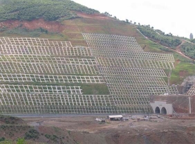
Many geological disasters occur frequently in mountainous and hilly areas of China, which seriously endanger the safety of life and property of the people, and have been paid great attention by the state and the people all the time. effective slope safety monitoring system is one of the most effective ways to ensure smooth roads and timely response to disasters. The vigorous development of internet plus technology has led to the development of information technology in the field of geological safety monitoring. the design and development of this system aims to develop a set of monitoring system with high measurement accuracy, strong real-time communication and convenient interaction by using Beidou satellite navigation system, internet and wireless communication technology.
Along with the civil process of Beidou satellite navigation system in China, Beidou satellite system technology is used for highway slope and bridge deformation monitoring, not limited by visibility conditions, flexible selection, real-time monitoring, high automation, according to the monitoring needs, monitoring points can be arranged on the deformation sensitive characteristics. Compare with that traditional manual periodic detection, the method has the advantages of high positioning accuracy, faster emergency response speed, strong automation degree and real-time observation capability.
With the development of China's strategic needs and as an important national behavior, the development of Beidou satellite navigation system in recent years is very rapid, and according to the characteristics of the global navigation system, navigation system and its industry in four major changes:
The transition from a single GPS era to a truly real-time multi-constellation compatible GNSS ( global navigation satellite system ) ushered in a new phase of satellite navigation system globalization and enhanced multi - mode;
From the satellite navigation system as the main body into positioning, navigation and timing ( pnt ) and wireless mobile communication and internet information carrier high integration of the new era, create a new stage of information fusion and industrial integration and application intelligence;
From the distribution of industrial products to gradually transformed into a new situation based on operational services, thus creating a new stage of application popularization, service industrialization and information intelligence;
From outdoor navigation system to indoor and outdoor seamless navigation and positioning of the new space-time service system of the new era, creating a satellite navigation system as the cornerstone of the multi-means integration, integration of heaven and earth, extensive service and intelligent new stage
System characteristics
The design objectives of the system shall be met
( 1 ) the slope static displacement measurement accuracy reached millimeter level, in order to meet the needs of medium and long-term monitoring.
( 2 ) the monitoring system is unattended in the field and has 7 × 24 h continuous working ability.
( 3 ) the location of the monitoring system generally does not have the communication conditions, need to use wireless transmission mode and the level of monitoring center for real-time communication.
( 4 ) the slope landslide has the ability to alarm, and the slope displacement, deformation trend prediction.
( 5 ) the maintenance department can be real-time view and analysis of the situation of each measuring point.
Technical principle
Relative positioning between 2 or more stations, as shown in the figure below, if points a and b observe the same set of satellites ( at least 4 ) at the same time. And a is a known point, through some kind of data chain, the original correction information to point b, then the location of the point b will be very accurate, static millimeter level accuracy.
System design and implementation
The selection and implementation of Beidou receive can be replaced by a linear change model in a local time interval due to that slow change of the monitor position; At present, the static differential measurement technology has been more mature, which provides a theoretical basis for the displacement monitoring of the system. Therefore, based on the static difference technology, it is reasonable and can meet the needs of the system to improve the measurement accuracy through continuous observation of 1 ~ 2 h, at the expense of time resolution.
In the selection of equipment, according to the static measurement test, in positioning accuracy, BD / GPS dual system is better than single system BD or GPS, BD / GPS dual system in horizontal and vertical precision are significantly improved, static positioning accuracy can reach millimeter level. Considering the requirement of long-term observation precision of slope, the system adopts BD / GPS dual system.
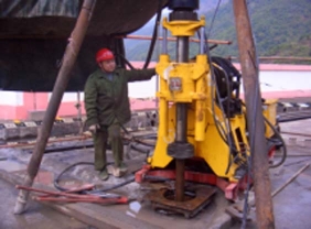
Bd / GPS receiver is installed in the monitoring area, as the measuring station of the monitoring system, installed in the sensitive area, the RTK differential measurement method is used to form the monitoring area network, the reference station selects the terrain safety and stability area for distribution, so as to ensure the data reliability of the monitoring system.
At the same time, the system carries on the comprehensive monitoring to the slope: install several groups of inclinometer system in the deformation sensitive part of the slope, which is used to monitor the deep deformation; A weather station is arranged below the slope to collect environmental information such as rainfall, temperature, humidity and the like of the slope so as to comprehensively analyze, predict and early-warning the slope state.
Communication mode and system architecture
The slope monitoring system consists of a sensor system, an information acquisition system, a communication system and an analysis and monitoring software system. The communication system is mainly composed of two parts: the communication within the slope area, and the communication between the slope and the monitoring user. In order to ensure the stable transmission and real-time storage of data, optical fiber communication is adopted. Because the slope is several kilometers away from the nearest communication facilities, do not have the conditions to set up a wired communication line, so the slope and monitoring users need to use wireless communication scheme.
The wireless transmission module in the system can carry out wireless data communication through a public network wireless communication module and a ZigBee pipe network system, the system mainly utilizes a 3g internet of things module for wireless transmission, and the mobile phone card is inserted to purchase flow for operation, so that the system is convenient, rapid and high in reliability. The 3g internet of things module is based on the Unicom 3g network, integrates voltage, current, switching value acquisition and control technology ( RTU ), serial port data transparent transmission technology ( dtu ), Beidou positioning technology as one of the industrial level internet of things module, has RS232 and RS485 serial port, the serial port equipment data through the 3g network long-distance transmission, realize from user equipment to user software system between wireless, remote, bidirectional data communication function. Can be configured with physical sensors, such as temperature, humidity, pressure, acceleration, gyroscope, geomagnetic sensor, etc.; Can be used in indoor and outdoor, indoor use using metal shell, protection level ip30 ( dust is not waterproof ), in outdoor use using metal shell and cast aluminum waterproof case double protection, protection level ip65 ( dust and waterproof ); It is mainly used in the industrial environment of dispersed user equipment, difficult field wiring and remote operation.
Rtk - gbg 810, RTK - gbg 820, RTK - gpg 610 series receiver is a high-precision multi-data interface multimode satellite receiver independently developed by Beijing century lianxin technology co., ltd., including base station, measuring station, antenna system, according to the different application scenarios are divided into linear ( RS232 / RS485 / RS 422 / Ethernet ), wireless ( 3g / 4g / wifi / ZigBee ) and other products, support disconnection reconnection and reverse control. The use of a strong ip65 protective shell, with high pressure resistance, dust and water resistance, can work in harsh natural conditions for a long time.
Monitoring software design
The software of slope monitoring system mainly completes the standardized conversion, storage, analysis, processing and evaluation of monitoring data of slope shape and working environment collected by hardware equipment. based on the b / s structure, the web service management center is developed by using ace framework, so that users can view the slope condition at any time and place under the networked state ( public network or local area network ).
The system has the following functions:
( 1 ) to configure and manage the event transaction ( project ), dictionary, etc
( 2 ) complete monitoring data display, query, release.
( 3 ) complete the historical data characteristic statistics, trend analysis.
( 4 ) to complete the slope state assessment, safety warning.
( 5 ) to complete the standardization of data conversion and storage.
( 6 ) complete the file and report management.
( 7 ) complete the map, the surrounding environment, system configuration and user rights configuration and management.